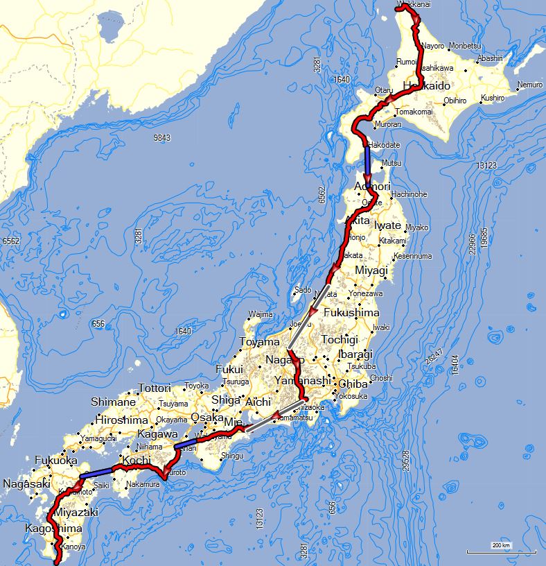
Cycle from the 45th parallel to the 31st in one event!
Click here for the Length of Japan – South to North version.
A visit to Japan is pure indulgence for the senses, so come prepared to experience a rich history that dates back centuries and to soak up after a day of cycling in zenlike onsen spas; visit beautiful forests, mountains and sea coasts as well as futuristic architecture and transportation; sample delicious regional cuisine; meet polite and candid locals as well as lovers of Hello Kitty and karaoke.
Photo: Robert J. Mang
Duration: 30 days / 31 nights.
Season: From 1 September til 31 May. Private guided tours upon request.
Calendar. If the tour is not scheduled or the dates in the calendar don’t suit your travel schedule, please contact us for a private or custom tour for you and your group.
Start: Wakkanai.
End: Ibusuki. Transfer possible to Kagoshima Chuo Station or Kagoshima Airport.
Level 4: Riding distances of 100 km or more with steep climbs. For riders in excellent condition.
Rental Bike Details
Price
Booking
Guide: Robert J. Mang solo-cycled this Length of Japan tour over 2013, 2014 & 2015. He now wants to share his joy with as many people as possible. Come and join him !
Robert is a photographer and print maker living in Santa Fe, NM, specializing high-quality studio photographs of 2d and 3d works for the fine artist and artisan. Additionally, he hand-produces fine-art prints using alternative processes, primarily Platinum and Palladium. He also creates premium black and white prints using carbon-based pigment inks. His photo site is here.
Robert spent 30 years in marketing and strategy development for one of the world’s largest wood products companies. Photography has always been a deep interest, and after leaving the corporate environment in 2009, he has been able to spend full-time further expanding his photographic expertise.
He also spends a lot of time on his bike. For the last three decades, he has cycled an average of 5,000 miles each year, and has been on tours in over 12 countries, including most of Western Europe, Tibet, Peru, and Japan. His cycling and travel site is here.
Cycle the Length of Japan – 2015
HIGHLIGHTS
- Cycle from the 45th parallel to the 31st in one event!
- Soak in outdoor onsen hot springs
- Enjoy exquisite Japanese cuisine
- Ride up Mount Fuji
- Dance the awa odori in Tokushima
- Visit the Hells in Beppu
- And finally… enjoy a well deserved steaming sand bath in Ibusuki !
TRIP STATISTICS
- ride days 28
- 8 ride days on Hokkaido
- 10 ride days on Honshu
- 10 ride days on Shikoku+Kyushu
- 2 train days (Honshu)
- 4 ferries
- total distance 2,500 km
- total elevation gain 30,000 mt
- average day 92km
- average gain 1100 mt
- 2 longest days 144km/136km
- 2 biggest climb days 2500mt/2400mt (Fuji-san and lower Kansai)
ITINERARY
Day 0 – 0 km: Welcome to Wakkanai !
Our trip starts in Wakkanai, the northernmost city in Japan. Wakkanai is a small fishing port with a regular ferry that brings day tourists from the Russian Island of Sakhalinskay.
You arrive in the course of the day at the hotel. Please note that your room may not be available until check-in time at 3pm, however if you arrive early the hotel will keep your luggage secure if you want to do some exploration. The tour officially starts with a group meeting and bike set-up at 6pm followed by the welcoming dinner at 7pm.
Day 1 – 96 km: Wakkanai to Hamatonbetsu
As we leave Wakkanai, our first 40km segment of riding takes us north to Cape Soya, the northernmost point of Japan. After a group photo at the Soya Monument, we immediately head south which is our general direction for the next 2600 km’s 😉 Our flat route today is along the coast where we’ll see massive piles of scallop shells along the deep blue coastal waters of the Northern Pacific Ocean.
Day 2 – 114 km: Hamatonbetsu to Nayoro
Leaving the coastal town of Hamatonbetsu we head inland to venture into the lush interiors of Hokkaido. We’ll have a slightly longer day, but still quite flat. It’s usually along this section where the sounds of our bikes will be drowned out by the loud chirping of crickets as they dominate the local sound-scape.
Day 3 – 80 km: Nayoro to Asahikawa
We leave the small town of Nayoro and head down a quiet river valley dotted with farms to Asahikawa, the second largest city in Hokkaido. The city is dense, but geographically small, so in less than 10km we enter and leave the city limits. For dinner, we’ll be sure to have the town’s signature dish, ramen.
Day 4 – 64 km: Asahikawa to Furanosho
Our 4th cycling day takes us to the ski town of Furano that receives over 8 meters of snow each winter. This will be our first taste of the hills of Japan; we’ll be seeing plenty more as our journey progresses.
Day 5 – 112 km: Furanosho to Sapporo
Today we head to Sapporo, the largest city in Hokkaido (and the 5th largest in Japan), known for hosting the first Winter Olympics in Asia in 1972, and for its famous Sapporo Brewery which we can tour if we arrive early enough after a long day on the bikes.
Day 6 – 104 km: Sapporo to Toyako Hot Springs
This will be our largest climbing day so far as we leave Sapporo heading into the Kimobetsu foothills up over the 837m Nakayama Pass. We spend the night along the placid Lake Toyako; known for its many hot springs.
Day 7 – 139 km: Toyako Hot Springs to Onuma
Today we take a coastal route that winds us around Uchiura Bay where we’ll have a clear view of the active volcano Mount Komagatake that dominates the skyline of our destination, the shores of Lake Konuma in the Onuma Quasi-National Park.
Day 8 – 34 km: Onuma to Hakodateko FERRY – Aomori
After leaving Onuma, we head to the ferry port at Hakodateko across the hilly Kameda Peninsula. We crest the peninsula at the 568m Nanaedake Pass. We take the 4-hour ferry ride to Aomori on the northern coast of Honshu. Aomori sits at the base of the massive Aomori Bay and enjoys one of the highest snowfall records on Earth.
Day 9 – 72 km: Aomori to Towada-Ko
Today is our first of 10 cycling days on Honshu. Our route out of Aomori is one of my favorite stretches of road in Japan. After only a few kilometers from the city center, we slowly wind upwards through some of the best cycling so far. Near our first summit we will stop at one of the courtesy roadside tea stands and take a break before our next section of climbs. The views along this road are breathtaking. The descent takes us deep into wooded parklands as we cycle through miles of dappled shade. We end at Lake Towada after an exhilarating day with over 72 km’s and 1800 meters of climbing on beautiful scenic roads.
Day 10 – 139 km: Towada-Ko to Kakunodate
We leave earlier than normal today to climb out of Towada-ko as we work our legs winding upward through the seemingly endless hills of northern Honshu. This will be one of our biggest days on the bike with over 135km, and 1900mt of climbing. We end in the ancient castle town of Kakunodate. Our plan is to arrive early enough to walk through the historic Samurai Village before dinner.
Day 11 – 136 km: Kakunodate to Sakata
The first half of today’s route takes us west to the coast by way of small rural roads with a few climbs, but mostly through a patchwork of farms and connected river valleys. The second half of the day is a flat coastal ride that meanders along the adjacent foothills that fall steeply into the sea. Our destination is the small town of Sakata, the “”city of rice””; know for its old rice storehouses. Today we pedal over 135km, but with little climbing overall. We stay at the delightful Wakaba Ryokan.
Day 12 – 96 km: Sakata to Murakami
Our ride to Murakami follows the coastal road passing fishing ports on a flat, easy day of cycling. Murakami is known for its salmon, which can be seen hanging from many local shops, and even the train station!
Today is Japan’s National Respect for the Aged Day… so be nice to everyone over 60!
Day 13 – 0 km: Murakami to Nagano – TRANSFER
Today is a rest day where we transfer to Nagano. We’ll have plenty of time in Nagano to visit its famous Zenkō-ji, a 7th-century Buddhist temple that overlooks the city.
Day 14 – 72 km: Nagano to Sakuho
It doesn’t take long cycling out of Nagano to understand why it was home of the 1998 Winter Olympics. The hills start quickly, and continue. This is a fantastic cycling route, often used by local clubs for their hill training. The beautiful surfaced roads are quiet, and are a joy to ride.
Day 15 – 104 km: Sakuho to Kofu
Leaving Sakuho we start out along the Chikuma River basin. But don’t be fooled, the road eventually turns upwards giving us two big climbs. Much of the route is on very small roads that twist and turn through the rural mountainside. We end in the flat river valley near Kofu.
Day 16 – 64 km: Kofu to Fujinomiya
The ride today is longer than yesterday, but overall not has hilly, as we head to Fujinomiya, which sits at the base of Fuji-san, the world famous UNESCO Cultural Heritage site. Depending on the weather, we should start seeing Mount Fuji about half way on our route. We pass by two of the famous Fuji Five Lakes: Lake Shoji and Lake Motosu. Fujinomiya is a starting point for many hikers and visitors going to the mountain.
Day 17 – 72 km: Fujinomiya to Mt Fuji/Return
Today will be a ride to remember, and the biggest climbing day by far. We’ll do an out and back route to Mount Fuji 5th Station that covers 72 km’s and climbs 2364 meters. The ascent starts slowly within a kilometer of our hotel, but once we leave the industrial fringes of Fujinomiya, the climbing really starts. There are no elevation drops as we continue up and up to the parking area of Station 5 on the south side of the mountain. This 3-4 hour climb is a cycling meditation, with all our energies going into being on the bike. This ride challenges many of the classic European Alps climbs, and will be a noteworthy personal achievement for us all. And then… get ready for the downhill!
Day 18 – 0 km: Fujinomiya to Igaueno – TRANSFER
We will have a leisurely start today, and our legs will thank us for this being a rest day. We transfer to Igaueno near the intersection of Kyoto, Nara, Shiga and Mie prefectures.
Day 19 – 96 km: Igaueno to Gojo
After a flat 20km leaving Igaueno, we pass the small town of Nabari in Southern Kansai. Once leaving Nabari, we follow a hilly route on tiny roads that create a serpentine path through the quiet mountains. Much of this route is almost like being on big bike lanes, just wide enough for one car. There are many beautiful and remote sections of road throughout these wooded hills. We end in Gojo, which sits along the Yoshinogawa River.
Day 20 – 72 km: Oyodoko to Wakayama FERRY – Tokushima
Today is a short, mostly downhill ride to the ferry at Wakayama. The 2 hour ferry takes us to Tokushima on the Island of Shikoku. Shikoku is noted for being home to Japan’s most famous pilgrimage route – The 88 Temple Pilgrimage (hachijūhakkasho-meguri), a 1200 km loop around the island founded by Kobo Daishi in the early 9th century. We’ll have plenty of time to explore Tokushima, a mid-size modern Japanese port city, home to Temples #13 through #17.
Day 21 – 96 km: Tokushima to Kaiyo-cho
We follow the coastline along the Kii Channel and then along the Pacific Ocean. For the coming two days we’re on the heels of the ohenro, the 88 Temple pilgrims and we’re sure to see some of them today, although it is a bit late in the season to start the pilgrimage.
We leave Tokushima on the boards of Katsuragawa River, then cross to the banks of Nakagawa River and further upstream on Akamatsugawa River. We crest at 185m before plunging down to the Anan coast. The deep blue Pacific Ocean is influenced by the strong Kuroshio Current. Long way away from cities & factories, the seawater is extremely clean with abundant marine life including rare sea turtles visiting the coast in crowds to lay their eggs every summer. Shishikui and Ikumi are also known as surfer’s Mecca’s.
Day 22 – 128 km: Kaiyo-cho to Kochi
We ride the beautiful shorelines throughout the day today. Soon we reach Cape Muroto. Kobo Daishi found enlightenment on this gorgeous, wild cape, and it’s easy to ponder why as you reach the ‘doorway to the land of the dead’. We round the cape and head back north towards Kochi.
We stop to admire the old streets of Kiragawa. Through late 19th into early 20th century, Kiragawa town prospered thanks to its high quality charcoal called Tosabinchotan. The streets with old buildings of charcoal dealers and shipping agents still retain the culture, history and atmosphere of the old days. We see traditional building techniques peculiar to typhoon-prone Kochi such as Tosa plastered walls, with their rows of water draining tiles, and windbreak fences called ‘Ishiguro’ made of round stones.
Nearing Kochi we enjoy riding on an old railway turned designated cycling path. Soon the 400-year-old Kochi Castle rises gloriously above the Kochi skyline, symbolising the spirit and heritage of Kochi.
Day 23 – 136 km: Kochi to Okawa
This will be another long and hilly day as we cycle due west through the quiet and twisty roads of central Shikoku. First along Niyodogawa River. Above Odo Dam the name mysteriously changes to Omogogawa River. Then further up Kurokawa River, gradually rising all day to end at our very traditional farm stay in Okawa at 460m.
Day 24 – 32 km: Okawa to Yawatahama FERRY – Beppu
We have a good pedal today to the ferry at Yawatahama, with some great downhill. But first the last bit of upstream along Kurokawa River, through the tunnel at 620m. Then a good downhill and a picturesque stop in Uchiko, a true photographer’s dream. The town got wealthy thanks to tree wax and became even a global exporter. Entire sections of Uchiko have been perfectly preserved as a living museum, where people still reside and where traditional crafts are still alive. The candle shop may be the only place where Japanese candles are still made using the traditional method. We have 300 more meters to climb out of town for a glorious approach to the Yawatahama Ferry Port.
From the ferry we finally see steam rising above Beppu, the famous hot-spring town on the island of Kyushu, producing more hot spring water than any other resort in the country. Time to relax in the soothing hot waters of Beppu Onsen.
Day 25 – 104 km: Beppu to Hagenoyu
We visit some of Beppu’s 7 Hells. Then another hilly ride from the hot spring town of Beppu to the volcanic mountain region of Oguni. We have lunch on the scenic shores of Lake Kinrinko in touristic Yufuin. A short stretch on the beautiful thus busy Yamanami “”Waves of Mountains”” Highway between Beppu and Aso, then quieter routes to the heartland of Oguni. There’s hot springs aplenty here, and we thoroughly enjoy Hagenoyu Onsen.
Day 26 – 128 km: Hagenoyu to Yatsushiro
This morning we have the climb up Mt. Aso caldera on the menu, so an excellent moment to take the Soba ‘Buckwheat’ Road. Riding on the rim with marvellous views of the volcano range that makes up Mount Aso. We stare down into the massive Aso Caldera, the largest in the world, measuring over 120km in circumference. The caldera was once a lake, and legend is that one day the god of the mountain kicked open the only break (through which rail and bus pass) emptying the water and leaving the plain fit for cultivation.
The area was hit by a severe earthquake in April 2016, crippling the roads leading into the caldera, so we are forced to swing around the caldera on the Milk Road. Then a fun downhill and crossing Shirakawa River towards Mashiki. Mashiki was the epicentre of the April 2016 earthquake. Here and there damage is still visible; repairs are ongoing. We follow Akizu and Yakata Rivers until just before Lake Etsuko; then Kasegawa and Midorikawa River further downstream to cross the fertile Kumamoto – Yatsushiro Plain. Our ride ends in the perfectly flat farming delta that surrounds the port city of Yatsushiro.
Day 27 – 80 km: Yatsushiro to Izumi
We dance a tango with a little railroad and continue along the splendid Shiranui Sea. Mitachimisaki and Ashikita Beach merit a stop. Without noticing we arrive in Izumi, winter resting grounds for Siberian cranes and home to Japan Biking. We visit the samurai residences before another hot bath to finish the day.
Day 28 – 88 km: Izumi to Kokubu
You won’t see the sea today, it is an inland ride. After a leisurely warm-up along Hirosegawa River we start climbing again, all the way up to Utsura Tunnel (378m). After the descent we reach the spectacular Sogi no Taki Waterfall. Here we have lunch. We then cross Sendai river and continue on Koganero Road up and down through the rice fields and some beautiful forest roads.
Day 29 – 88 km: Kokubu to Minamiosumi
A whole day along Kinko bay with views on Sakurajima Volcano and a visit to the Kurozu amber vinegar brewery. We end in Minamiosumi, within reach of Cape Sata.
Day 30 – 80 km: Minamiosumi to Sata (rt) – Nejime FERRY – Ibusuki
On our last day cycling we head for Cape Sata at the southern tip of Kyushu. Cape Sata lies just below the 31st Parallel and is the most southerly point in the main Japanese archipelago. This last ride will be hilly, ending at the access tunnel for the Cape. If our legs are up to the challenge, we can make the final 30 minute hike to the Sata Monument (no bikes allowed) overlooking the deep blue waters of the East China Sea to our right, and the North Pacific to our left. We backtrack to Minamiosumi to take the ferry across Kinko Bay to Yamagawa. A short final ride to Ibusuki and that’s it. You’ve made it !
Day 31 – 0 km: Sayonara !
Then it is time for final goodbyes… after breakfast you don’t have to climb in the saddle any longer. Now you are freed from the chores of the road.
Onwards…
- Explore the sultry city of Kagoshima and do some souvenir hunting.
- Set out to UNESCO world heritage Yakushima, a subtropical island 4 ferry hours south of Kagoshima. Yakushima makes for some great hiking or biking.
- Transfer to Kagoshima Chuo Station or Kagoshima Airport.